

Inca City of Ollantaytambo
Ollantaytambo is a small town in the Sacred Valley en route from Cusco to Machu Picchu. Its appeal to me is that it still retains so much of the original Inca city, that it is easy to imagine that it is 600 hundred years ago, and an Inca priest or noble might appear round the next corner.
The Sacred Valley was inhabited by Ayamarcas who migrated from the Titicaca area. Pachacutec invaded the area in the mid-15th century, and after his death, it was given to a branch of his extended family. They expanded the agriculture, farming every available piece of land, by building terraces and irrigation systems. The Urubamba River meanders through the valley, so they improved the flow by straightening out some of the bends, and irrigation channels led from the river. The streams fed by the melting snow of the high surrounding mountains were harnessed to water the upper terraces. The also built a bridge to the other side of the river, to connect with the Inca road system The central buttress can still be seen, and supports a modern suspension bridge. In Inca times the bridge would have been of rope made from plaited grasses, which would have been renewed every year.
 So Ollantaytambo developed as an agricultural centre, but it was also strategically placed to
defend the northern entrance to the valley from there traditional enemies, the Antis, who lived
in the jungle areas to the north east. Its name is derived from "Ollantay", a captain in the Inca
army who was in love with one of Pachacutec's daughters ( the story is the subject of a popular
drama) and "tambo", the Spanish version of "tanpu", a Quechua word meaning a place offering hospitality
to travellers. Inca cities were where nobles, priests and administrators lived., servants lived
on the outskirts of the city and farmers lived on the land.
So Ollantaytambo developed as an agricultural centre, but it was also strategically placed to
defend the northern entrance to the valley from there traditional enemies, the Antis, who lived
in the jungle areas to the north east. Its name is derived from "Ollantay", a captain in the Inca
army who was in love with one of Pachacutec's daughters ( the story is the subject of a popular
drama) and "tambo", the Spanish version of "tanpu", a Quechua word meaning a place offering hospitality
to travellers. Inca cities were where nobles, priests and administrators lived., servants lived
on the outskirts of the city and farmers lived on the land.
Approaching the town, the modern road wends its way up and along the top of a large, solid stone terrace, which had also served a defensive function; thence through narrow streets to the main square, where the colourfully dressed descendants of the Inca people sell handicrafts and cool drinks.
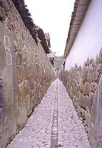
Leading from the square are several blocks of narrow streets, which are almost exactly as they were then, with clean water still flowing in channels. Each block contained two homesteads of important families, each opening onto a courtyard, but with only one door, and no windows to the street, so the houses are dark inside (although now they are supplied with electricity). The doors have the double jambs, which indicate that they belonged to the elite. The walls show typical Inca stonework, but were probably originally covered in a clay coating, and perhaps painted with murals. The roofs were originally thatched, but now are finished in red tiles. Large supporting stones are found at the corners of the blocks.
To the west is a huge trapezoid plaza Manay Raqay, with several large adobe brick buildings. Children dressed in the typical dress of the Cusco region -(red dresses with a disc-shaped hats decorated with a white wheel-like pattern), pose for photographs in exchange for small change.
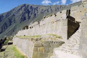
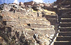 Above this area is a series of 16 terraces leading up to what was probably a collection of temples,
including the Sun Temple. The terraces probably grew maize for ceremonial purposes. I puffed my
way up to the top (remember it is nearly 10,000 feet above sea-level), thankful when the guide
stopped to point out items of interest, such as the Temple of 10 Niches", which was perhaps where
the mummies of the Inca nobles were kept.
Above this area is a series of 16 terraces leading up to what was probably a collection of temples,
including the Sun Temple. The terraces probably grew maize for ceremonial purposes. I puffed my
way up to the top (remember it is nearly 10,000 feet above sea-level), thankful when the guide
stopped to point out items of interest, such as the Temple of 10 Niches", which was perhaps where
the mummies of the Inca nobles were kept.
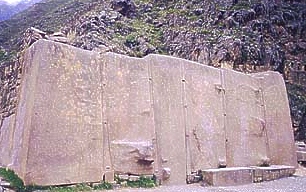
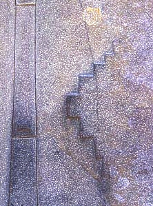
The Sun Temple is made of huge blocks of pink granite, weighing up to 90 tons, which were cut from a quarry on the opposite bank of the river. How did they manage to transport these massive boulders across the river and up the hill? A channel was dug parallel to the river, so that the flow could be diverted, and the blocks of stone moved on wooden rollers across the river bed. Then the channel was emptied, and the blocks moved across it. A ramp was built to the top of the terraces, and using a system of pulleys, rollers and massive manpower, the stone was brought to the construction site. Some large stones are visible at the top of the ramp. Are these "tired" stones, unsuitable for building use, or was the building incomplete? It is argued that the finish was such that it must have been completed - sketches from the 19th century show that the walls were more intricately carved than is evident today, because of weathering. The main surviving wall is a wonderful example of the workmanship of Inca stonemasons. The stones were cut so that projections from one fitted into a recess in its neighbour, they fit together so accurately that you can't even insert a credit card between the stones. Our guide suggested that the large projections on the wall were to help in lifting the stones, and they would have been trimmed off later, suggesting that perhaps the temple was not completed, but others suggest that these were decorative, perhaps carvings of gods of Inca mythology, which were destroyed by the Spanish. Notable on one of the stones is the stepped design, chacana, representing the 3 levels of the Andean world: Hanan Pacha (sky), Kay Pacha (earth) and Ukhu Pacha (underground). This symbol is found in extensively in Tiahuanaco.
Inca Wall
Wall Detail
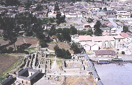
From the vantage point at the top of the terraces there is a wonderful view across the Sacred Valley, with the town of Ollantaytambo lying below, and above it, the granary. This building, on Pinkuylluna hill was used to store grain and other produce. It had many windows and doors, for ventilation to keep everything fresh.
To the north, along the Patakancha stream are found a series of ceremonial fountains, probably associated with water gods.
Following the siege of Cusco, Manco retreated to the Sacred Valley, making his headquarters in Ollantaytambo, which he further fortified, and expanded to house his army. He had captured some Spaniards and their weapons, and forced them to make gunpowder. He also had archers from the jungle. When the Spanish army approached, Manco rode a Spanish horse and brandished a Spanish sword. The invaders were attacked by the devastating archers, gunfire and rocks hurled from the terraces. In addition, the Patakancha river was dammed, and the dam opened, flooding the area, so the Spanish horses were bogged down in the mud. Thus the Incas won the battle. However, Manco realised that this victory could not be maintained, and retreated across the mountains into the cloud forest area to Vilcabamba. He accepted that his people would be forced to accept the invaders' ways, but told them to always remember their own religion in their hearts.
Many of the indigenous people were killed or died of western illnesses, and the population dwindled. The Spanish conquistadors were only interested in finding gold, not in agriculture, so the terraces and irrigation systems fell into disuse, and a once rich area became poor.
Ollantaytambo Today
References: Qosqo, Ollantaytambo: A Living Past - Stephen Light, and Conquistadors by Michael Wood.
The source for more information on the cities of the Incas is a wonderful book
(certainly worth buying or checking out of the library) called "The Cities
of the Ancient Andes" by Adriana Von Hagen and Craig Morris.
